site templates free download
Mobirise

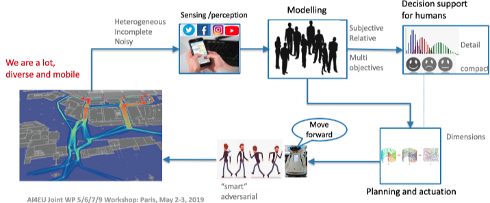
Physical AI refers to the embedding of AI methods and techniques in the physical world.

Physical AI systems take input about the state of the physical world through sensors, or modify the state of the physical world through actuators, or both.

The application of AI in the physical world calls for robust methods that can deal with issues like uncertainty, limited data availability, or limited computational resources. Many AI methods and tools rely on assumptions that do not easily accommodate these issues.

The AI4IoT Testbed

The work in PhysicalAI is stronly influenced and developed in collaboration with the AI4IoT pilot(Task 6.8). Sinergies were identified in the joint workshop in Paris and collaborations were established between teams. Data was shared by Telenor/NTNU and some tools tested and/or under development. 

The IoT testbed comprises a set of 4 pollution sensors (static, high precision) and many microsensors installed in fixed locations and mobile as well.

Mobirise


The setup of the AI4IoT Pilot (Task 6.8)

Our test cases were developed in close collaboration with the IoT pilot testbed that runs in Task 6.8. Data was provided by Telenor and NTNU collected from Norwegean public entities and Telenor's own IoT network. We focused on Trondheim as the main scenario.

Mobirise

Environmental Data

The goal is to create a common dataset and a set of tools that can be applied to several problems: estimate pollutants, forecast and simulate city emissions to test control actions

Results data and details check on the test cases.

Focused Research Topics

Planned after a workshop with all AI4EU Pilots (WP6), Physical AI proposed to develop four test cases where tools will be adapted and/or developped and tested in a real scenario.
The topics are :

Elastic Methods for Time Series

TUB

Develop time-elastic methods for classification and clustering problems such as estimating Remaining Useful Life (RUL) or probability of failure within a specific time window

Missing Data

ISTR

Investigate methods to tackle the problem of extracting information (data completion and clustering) from high dimensional (possibly heterogeneous) incomplete sensor data collected in large areas or missing for relatively large periods of time 

Vehicle Counting in Images

CNR

Images captured from city cameras can convey relevant information for indirect estimation of pollution from traffic sources by counting cars in the images. Data coming from car counting might be related with pollution data coming from other sensors so that decisions about car traffic management can be taken more confidently. 

Large Data Sequential Decision-Making 

ISTR

Using decision-theoretic methods to provide dynamic sensor placement or selection, under uncertainty of the sensor observations, the action outcomes, and the effects of actions on observations, as well as the heterogeneity of the acquired data and the absence of data about some of the relevant variables to map the pollution.